Gilgit Baltistan

gilgit baltistan land marks

Gilgit Baltistan Wonders

Gilgit Baltistan, a land of towering peaks, diverse cultures, and breathtaking landscapes.

gilgit baltistan landmarks `

Nature & Culture

The Land of Majestic Peaks

Gilgit Baltistan, also known as the Northern Areas, covers 72,496 sq. km with towering peaks ranging from 1,000 to over 8,000 meters. The valleys of Gilgit, Hunza, and Skardu resemble Shangri-La. It consists of six districts: Astore, Diamir, Skardu, Ghanche, Ghizer, and Gilgit. The main languages are Shina, Balti, Burushaski, Khowar, and Wakhi. The population is entirely Muslim, with sects including Shia, Sunni, Ismaili, and Nurbakhshi. Despite its rich culture, education remains poor, especially for women. In 1981, female literacy was just 3%, while male literacy was 14.7%.

The region is also called Dardistan, Balawaristan, and Little Tibet. The Baltoro Glacier, the largest outside the Arctic, stretches 35 miles between towering peaks. It has one of the world’s highest concentrations of mountains, including K2 (8,611m), Broad Peak (8,047m), Gasherbrum I (8,068m), and Gasherbrum II (8,035m). Nanga Parbat (8,126m) stands at the Himalayas’ western edge. Additionally, 68 peaks exceed 7,000m, with hundreds over 6,000m. The region hosts some of the longest glaciers outside the polar zones, including Siachen (72 km), Hispar (61 km), and Baltoro (60 km).

Governance & Growth

Politics and Economy

Economic Situation

The economy of Gilgit Baltistan relies on subsistence agro-pastoral activities with limited agricultural productivity due to harsh climatic conditions. The region faces poverty, inadequate infrastructure, and scarce off-farm employment, with tourism being the primary sustainable industry. The construction of the Karakoram Highway (KKH) has revitalized trade, linking the area with China and Central Asia while fostering market towns and economic growth. A shift from staple crops to cash crops like potatoes and apples is emerging, primarily for trade with China.

Political Situation

Prior to 1970, this area was divided into small states, privately run by Mirs and Rajas. People did not have any political or civil rights. Mirdoms and Princely states were abolished in 1970 and the area came under direct administration of Pakistan Federal Government. Ministry of Kashmir Affaires and Northern Areas functionaries moved in and a controlled system of government from Islamabad replaced the traditional power centres. The current administrative set up is being run under direct control of Pakistan federal administered northern areas.

Economic situation

Exploring Ancient Settlements

Timeless Treasures of Gilgit Baltistan

There are nine major historic settlements. Five of these are located in the Hunza one in Nagar and three in Baltistan. Skardu is the only city amongst those enlisted, the rest are village settlements, though Karimabad is fast emerging as a township.

Baltit-fort-pak

Baltit Fort

Baltit Fort housed Hunza’s royal family, ruled by Mir Tham.

Attabad Lake

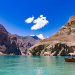
Attabad Lake, formed by a 2010 landslide, lies in Gojal region of Gilgit-Baltistan

Chaqchan Mosque

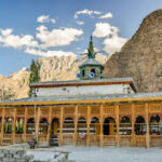
Chaqchan Mosque, built in 1370, marks Khaplu’s Islamic transition.

Rakaposhi

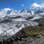
Rakaposhi, or Dumani, spans 20 km in Karakoram, Gilgit-Baltistan.

History, Culture, Legacy

Unveiling the Past

Discover the rich history of Hunza and Baltistan, where ancient settlements, sacred sites, and historic monuments tell the story of civilizations dating back to the 4th millennium B.C.

Buddha De Yasheni

Kargah Buddha is an archaeological site located about 6 miles outside of Gilgit, Gilgit−Baltistan, Pakistan. It is a carved image of a large standing Buddha, some 50 ft high, in the cliff-face in Kargah Nala. The carving, which is in a style also found in Baltistan, is estimated to date back to the 7th century.

Sacred Rocks of Ganish

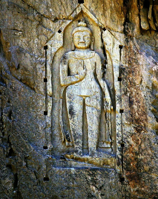
The Sacred Rocks of Hunza or Haldeikish constitute one of the earliest sites of Petroglyphs along the ancient Silk Route. It is a cultural heritage site in Gilgit-Baltistan region of northern Pakistan. The carvings on the rocks dates back to the 1st Millennium AD.

Baltit-fort-pak

Baltit Fort

Baltit Fort is a fort in the Hunza valley, near the town of Karimabad, in the Gilgit-Baltistan region of northern Pakistan. Founded in the 8th century CE, it has been on the UNESCO World Heritage Tentative list since 2004. The Mirs of Hunza abandoned the fort in 1945, and moved to a new palace down the hill.