Azad Kashmir, a land of lush valleys, majestic mountains, and a rich cultural heritage.
Azad Jammu and Kashmir (AJK) spans 13,297 square kilometres, characterised by hilly and mountainous terrain adorned with lush forests, rivers, and valleys. Elevations range from 360 to 6,326 metres, contributing to a sub-tropical highland climate. As of 2023, the population stands at approximately 4.361 million, with 88% residing in rural areas. The literacy rate is 74%, with primary school enrolment rates of 98% for boys and 90% for girls. Agriculture remains a cornerstone of the economy, with 13% of the land under cultivation, primarily producing maize, wheat, and rice. Fruit farming encompasses 14,460 hectares, yielding apples, pears, and walnuts.
4.361
13.2km²
2.41%
Azad Jammu and Kashmir (AJK) is administratively structured into three divisions—Muzaffarabad, Poonch, and Mirpur—encompassing ten districts, with Muzaffarabad serving as the state capital. The Muzaffarabad Division includes the districts of Muzaffarabad, Hattian Bala, and Neelum; the Poonch Division comprises Bagh, Haveli, Poonch, and Sudhanoti; and the Mirpur Division consists of Mirpur, Kotli, and Bhimber. These districts are further subdivided into 32 tehsils and 189 union councils, encompassing a total of 1,771 villages. Local governance is facilitated through elected bodies, including 5 municipal corporations, 13 municipal committees, and 18 town committees.
Azad Jammu and Kashmir (AJK) operates under a parliamentary form of government. The President serves as the constitutional Head of State, while the Prime Minister, supported by a Council of Ministers, functions as the Chief Executive. AJK has its own Supreme Court, High Court, and a unicameral Legislative Assembly comprising 53 members: 45 are directly elected, and 8 are reserved seats—5 for women, and one each for technocrats, Ulema (religious scholars), and overseas Kashmiris.
At the time of partition in 1947, the economy in Azad Jammu and Kashmir was on subsistence level but the determination to develop the area was there. It was early 70’s when economic development of the area started in earnest. Despite financial constraints, planners made good efforts in laying down a proper path for rapid development of the area.
Azad Kashmir, positioned on the Pakistani side of the mesmerizing Kashmir region, invites you to unearth its hidden treasures. Familiarly called “Free Kashmir,” this enclave is a haven of unspoiled landscapes, a tapestry woven with a rich cultural legacy, and a sanctuary of warm hospitality. Embark on this odyssey with us as we navigate the valleys, ascend the majestic mountains, and immerse ourselves in the cultural wonders that uniquely characterize this slice of Kashmir. Together, let’s unravel the stories etched in its pristine landscapes and explore the spirit of Azad Kashmir.
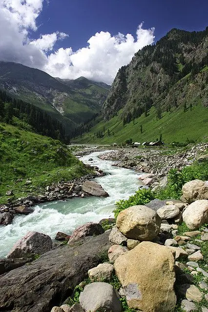
A lush paradise of rivers, mountains, and misty landscapes.
A glacial blue gem cradled by towering alpine peaks.
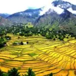
A serene valley of pine forests, golden fields, and wooden cottages.
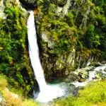
A breathtaking cascade hidden in nature’s green embrace.
Nestled between towering peaks and flowing rivers, Azad Kashmir holds a history as rich as its landscapes. From ancient civilizations to colonial struggles and the echoes of partition, its past is woven with resilience, cultural vibrancy, and the enduring spirit of its people.
Sharada Peeth is a ruined Hindu temple and ancient centre of learning located in the Neelum Valley of Pakistan-administered Azad Kashmir in the disputed Kashmir region.
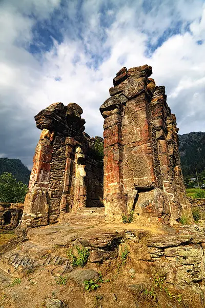
The tentative period of fort was dates back to the 16th century CE (TIAC, 2014). Many believe this was the work of Mughal emperors. Some say that it was built by the Sikh rulers after they had defeated Raja Sultan Khan the last ruler of Bhimber state in 1812.
“Ram” means ‘God’ “Kot” means ‘place’ so Ramkot means place of God (Aseer, 2003). This fort was primarily constructed by Muslim rulers in 16th century AD. Later fortified by Sikh Mahrajas. This fort is the perfect architecture of Muslim military strategy and filled with war mechanism (Ali, 2015).
A comprehensive look at the population, land area, and key statistics of 10 districts, providing insights into the region’s demographic structure and growth trends.
District | Area (Sq. Kms) | Population |
---|---|---|
Muzaffarabad | 1,642 | 650,370 |
Bagh | 770 | 371,919 |
Poonch | 855 | 500,571 |
Sudhanuti | 569 | 297,584 |
Kotli | 1,862 | 774,194 |
Mirpur | 1,010 | 456,200 |
Bhimber | 1,516 | 420,624 |
Hattian Bala | 854 | 230,529 |
Neelam | 3,621 | 191,251 |
Haveli | 598 | 152,124 |
Total | 4,045,366 | 4,045,366 |
Metric | Value | Unit |
---|---|---|
Male population | 1.685 | Million |
Female population | 1.665 | Million |
Gender ratio (males per 100 females) | 101.0 | Males per 100 females |
Average family size | 7.2 | Members |
Urban population percentage | 12.0 | % |
Rural population percentage | 88.0 | % |
Growth rate | 2.41 | % |
Population density | 0.66 | Persons/Sq.Km |
Literacy rate | 76.8% | % |
Muslim population percentage | 99.0 | % |
The Kashmir Freedom Movement is working for the integration, mobilization, and empowerment of the people of Jammu and Kashmir towards the self-determination cause. By civil resistance and advocacy, we shall try to create a just, independent, and modern welfare state.
© Copyright 2025 - KFMovement - All Rights Reserved.